Description
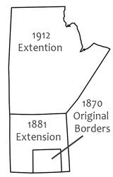
Manitoba’s borders were extended to reach the present-day Manitoba/Saskatchewan border in 1881.
Story: Manitoba's Borders
How this prairie province grew from a “postage stamp” into a “keystone.”
1870-1912
Manitoba was the 5th province to be added to the Dominion of Canada. It came about as a result of negotiations between Louis Riel (spokesperson for the Red River Métis) and the government of Canada at the end of the Red River Resistance. The Manitoba Act was passed in the spring of 1870 and brought the new province of Manitoba into the Dominion of Canada.
The original size of the province was only one-eighteenth its present size. It was referred to as the “postage stamp” province due to its square shape. The following decade saw thousands of settlers moving into the province and past Manitoba into the North West Territories. In 1881 Manitoba’s borders were enlarged in order to control the pattern of incoming settlement. Land mostly to the north and west was added to the province, quintupling its size. The Manitoba-Ontario border took a further 74 years to be determined. The town of Rat Portage (now Kenora), especially, was caught in the middle of an inter-provincial dispute over who was in control.
The present boundaries of Manitoba were set in 1912. The northern limit of the province runs along the 60th degree latitude and the northeastern part of the province was enlarged to border Hudson’s Bay.
Manitoba continues to be the gateway into western Canada. It is sometimes referred to as the “keystone” province of Canada: the centerpiece of the architecture of the country, holding everything in place.
. . . . .
Author: Teyana Neufeld
Source:
Kemp, Douglas. "From Postage Stamp to Keystone." Manitoba Pageant. 13 June 2009. Retrieved 6 Aug 2010. http://www.mhs.mb.ca/docs/pageant/01/boundaries.shtml
Graphic: Adapted from above source.